
Posted:
Fri Jul 01, 2005 2:43 amAuthor: kardox
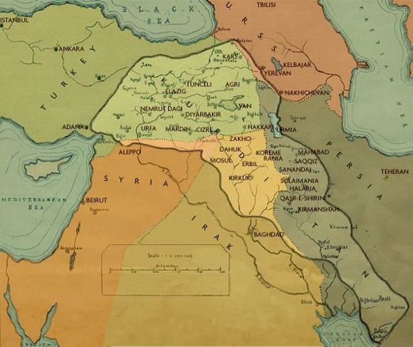
it must be bigger man  A friend of mine has made a Kurdistan map and he has send it to me and other friends. here is what he wrote:
Dear friends
I am fed up with all these incorrect maps of Kurdistan I see on different web pages. The following link leads you to the map of Kurdistan. To all Kurds in the mail list, if you don’t mind please forward this e-mail to any Kurd you know and/or to any Kurdish website you know. To those of you who are not Kurds it would be very kind of you if you forward this e-mail to any Kurd you know.
Best regards
and here is the map link :
http://www.itu.dk/people/arikurshid/arikurshidhome/
Posted:
Fri Jul 01, 2005 5:02 pmAuthor: Diri
This map which your friend made is aggrevating... I was expecting something that was gonna be 100% correct... But in this map Hemedan, areas north of Lake Urmiye and a LOT of areas in todays Northern Syria are NOT in Kurdistan... Why is this???
This map looks like the copy of the Map that was given to the UN by XOYBÛN in 1945 at the UN's first sumit in San Fransisco!
It looks just like THIS map:
Now - They are the same... RIGHT??? They look the same to me...
Posted:
Fri Jul 01, 2005 5:05 pmAuthor: Diri
The problem is - "Kurds" or what ever you wanna call them - in most southern part of Kurdistan - just North of the Persian Gulf are not nationalist... They have been mostly assimilated...
Posted:
Fri Jul 01, 2005 7:46 pmAuthor: kardox
Diri wrote:The problem is - "Kurds" or what ever you wanna call them - in most southern part of Kurdistan - just North of the Persian Gulf are not nationalist... They have been mostly assimilated...
hi diri , u are right , but it still is much better map than the once we have seen so far . you culd maybe email him and tell him the areas that he misses
Posted:
Sun Jul 03, 2005 5:30 pmAuthor: Diri
RIGHT! I will do that... WHERE IS HIS E- MAIL ADRESS BROTHER...????

Kurdistan Map
Posted:
Sun Jul 03, 2005 8:07 pmAuthor: Heja
I think there is a mistake in the map. "Hamadan" which was the site of the very first kurdish capital of Medyan Empire, isnot a kurdish city anymore. The overwhelming majority consider themselves to be turks, and they speak persian too. But the map is right about Pahla, and the south-eastern part which is called "Lorestan" in iran. But many inhabitants of northen lorestan consider themselves as kurds. Indeed they can easily learn sorani, sinec I have seen at least one person doing that.
About the very southern tip of Zagros(north of Gulf), Including "Bakhtiari" province in iran, I can say they are very similar to kurds, in clothes, traditions and language. But the problem is that they have been so much isolated that they have forgotten their roots. But there is a very nice evidence even today of a kurdish past. The provincial capital is called "Shahr-e-kord" in persian which means "The city of kurds" or "Sharî kurd". Persians stilllook down on them with contempt even today, since they are not considered genuine persians. Certainly different from the inhabitants of inner deserts of iran (Isfahan, Yazd, Kerman, Tehran).


